Fugawi UK Digital Maps 4.0

An advanced 3D ‘fly-through’ feature to bring the maps to life
Rating
Your vote:
Latest version:
4.0 See all
Developer:
North Port Systems Inc.
Screenshots
1 / 1
Request
Download
link when available

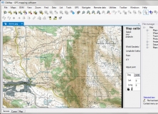
Fugawi UK Digital Maps™ offers a seamless view using the highly detailed Ordnance Survey® Landranger® or Explorer® maps.
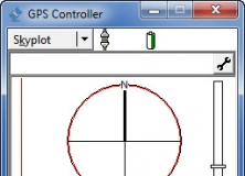
This is a brilliant and easy to use PC atlas with included GPS and PDA software.
An advanced 3D ‘fly-through’ feature is included to truly bring the maps to life.

Comments

User

Your vote:

Related software

OkMap
OkMap
Free
rating

Create waypoints, routes and tracks on maps and upload to your GPS device.

locr GPS Photo
locr GPS Photo
Free
rating

Add geotagging information to your photos.

GPS Controller
GPS Controller
Free
rating

Configure your Trimble Mapping & GIS GPS receivers.

TOPO! Explorer
TOPO! Explorer
Free
rating

Free desktop application created by National Geographic Maps

GPS-SNO
GPS-SNO
Free
rating

This application was created prediction of S-nitrosylation sites.

Tags

Uk maps Digital maps PDA Digital Maps GPS Fugawi Maps"